The Carolina Bays
Have you ever heard of the "Carolina Bays"? They exist, and they are probably not what you think! The Bays are very mysterious, and there appears to be no definitive scientific explanation for them.
I lived in North Carolina for a number of years and have visited South Carolina often. I had never heard of the Carolina Bays before I happened upon a geology website a year or so ago that talked about them. Apparently some people were aware that the mysterious Bays existed from as far back as the 1750's, however, the extraordinary magnitude of the phenomena was not understood until this aerial black and white photograph of the Myrtle Beach, South Carolina area was produced in the 1930s.
 |
| Aerial Photograph of land near Myrtle Beach, S.C.; from Cintos.org |
For the first time the tremendous number of Bays, or teardrop-shaped depressions in the earth's surface, was evident. It also became clear that these depressions were consistently oval in shape and were uniformly directional: always aligning northwest to southeast.
The Bays shown in the old photograph above are but a tiny fraction of the total number discovered. Research later showed that there are as many as 500,000 of these strange elliptical depressions -- all aligned in the same direction! While they are almost exclusively concentrated along the narrow coastal range of North and South Carolina, a few fan out into north Florida, Georgia, Virgina and Delaware. Geological formations of corresponding magnitude appear nowhere else on earth (though some have recently noted a very small number of similarly aligned eliptical ponds in the vicinity of Perth, Australia). The Carolina Bays are symetrical and shallow, not more than 50 feet deep. They range from 200 feet to 7 miles long and sometimes overlap one another. Some are filled with water, many are swampy, a large number are thick with varieties of bay trees (thus the name Carolina Bays), and some are dry. Over the years many have been drained and plowed for farming or put to other uses.
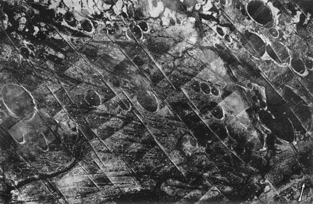
 |
| I can count at least 8 Bays in this photo |
In South Carolina, the Woods Bay State Park was established to preserve the Bays in that area from destruction:
 |
| Woods Bay State Park, S.C. |
In North Carolina, one of the larger Bays is now known as Lake Waccamaw; it drains into the Waccamaw river through Conway to the coast of South Carolina.
 |
| Lake Waccamaw, North Carolina |
Mysterious Origins
Over the years there has been much speculation about the origin of these strange formations. Early on, some scientists theorized that they may have resulted from the impacts of a meteorite swarm, while others speculated that they might have been caused by a comet colliding with Earth. Further studies have cast doubt on these "extra-terrestrial" impact theories for the source of the Bays. No evidence of impact crater formations has been found and there have been no residual meteorites discovered in the depressions. More recently, scientists have conjectured that the Carolina Bays may be the result of some sort of natural phenomena on Earth: a series of parallel artisian springs; consistent southwest winds blowing over existing lakes; or, somehow, they were created during glaciation. But despite years of study, there is still no consensus among scientists as to the origin of the depressions.
Following is a link to an impressive YouTube video on the Carolina Bays produced by "waccamawn." Watch it! http://youtu.be/-vNS27eXD60
The Carolina Bays are still a very peculiar mystery!


